


les terriers les arcs

ninia
User
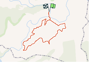

Length
10.1 km

Max alt
253 m

Uphill gradient
302 m
Km-Effort
14.1 km

Min alt
30 m

Downhill gradient
306 m
Boucle
Yes
Creation date :
2023-01-30 08:03:58.556
Updated on :
2023-01-30 11:16:05.02
3h11
Difficulty : Medium

FREE GPS app for hiking
 SityTrail
IGN / Geographical institutes
SityTrail Plus
The world is yours!
About
Trail Walking of 10.1 km to be discovered at Provence-Alpes-Côte d'Azur, Var, Les Arcs-sur-Argens. This trail is proposed by ninia.
Positioning
Country:
France
Region :
Provence-Alpes-Côte d'Azur
Department/Province :
Var
Municipality :
Les Arcs-sur-Argens
Location:
Unknown
Start:(Dec)
Start:(UTM)
298535 ; 4812078 (32T) N.
Comments